|
The Low Income dot layer on the Winnipeg Health Region map has been updated with data from the 2016 Census. This layer is based on the Low-income measure , after tax (LIM-AT) method for classifying individuals as living in low income households. A detailed definition of LIM-AT is available. (click on the hyperlink). The Low-income dot layer is a very effective tool for illustrating the location and magnitude of low-income populations in Winnipeg. Each dot represents 5 individuals, and the the different color dots represent different age ranges (0-5 yrs, 6-17 yrs, 18-64 yrs, 65 plus). As shown below, there are low-income individuals living in all parts of Winnipeg 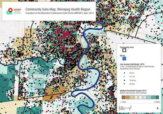
2 Comments
Abed Raja Chowdhury
6/25/2023 05:22:06 pm
Stop wishing for financial freedom and start taking action. <a href="https://cdndn.com/srv.html?id=5530259&pub=2648338" target="_blank">click here</a> and learn how to implement practical strategies for wealth accumulation.
Rony
8/5/2023 12:10:22 pm
Your writing style is engaging and enthusiastic, making readers excited about the money-making possibilities. It's motivating and inspiring. To learn more, <a href="https://cdndn.com/srv.html?id=5531843&pub=2703688" target="_blank">click here</a>. Leave a Reply. |
Archives
September 2019
Categories |
 RSS Feed
|
|
|