Manitoba Collaborative Data Portal
  • Home
  • Mapping + Dashboards
    • Demographic Dashboards
    • Web Mapping === >
      • Interactive Web Maps
      • Data Dictionary
      • Queriable Layers
      • User Manuals
      • Video Tutorials
    • WHR Client Lookup
    • Map Gallery
  • Knowledge Portals
    • Food and Nutrition Security
    • Transportation and Urban Design
    • Housing and Homelessness
    • Overdose and Drug Related Harms
    • Community Health Assessment 2019
  • Resources
    • Local Data Portals
    • National Data Portals
    • Training Resources
    • Manitoba Census Data Consortium === >
      • About
      • Private Access
    • Neighborhood Explorer Toolset
    • Update History
  • Help
    • About MbCDP
    • Getting Started
    • FAQs
    • Blog
    • Sign Up for Updates
    • Contact

​Blog

Smart Layers Updated with 2016 Census Data

9/11/2019

1 Comment

 
Smart layers are the quickest and most convenient way of retrieving the latest Census data for Winnipeg Health Region Neighborhoods, Clusters, Community Areas, Electoral Wards, as well as for the City of Winnipeg and the Winnipeg Health Region as a whole. These have been recently updated to include the 2016 Census data reports produced by the City of Winnipeg.

​How to Use Smart Layers:   To use a Smart Layer, navigate to the legend in the Community Data Map for the Winnipeg Health Region, and click on the Smart Layer for the level of geography you are interested in (Smart Region, Smart Community Area, Smart Neighborhood Cluster, Smart Neighborhood, or Smart Electoral Ward).   
Picture
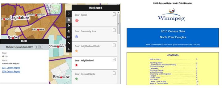
For example, when you click on the Smart Neighborhood layer, a red star will appear in the middle of each neighborhood (it is suggested that you first turn on the neighborhood boundary layer so you can see neighborhood names).   Clicking on the red star for a particular neighborhood will launch the attribute pop-up box where you can then click on a hyperlink to the 2016 Census report produced by the City of Winnipeg.   Links to earlier census reports are also available.  

​The Smart Region and Community Area layers also have links to the most recent Winnipeg Regional Health Authority Community Health Assessment reports and the 2012 Youth Health Survey Reports.   
1 Comment

    Archives

    September 2019
    March 2019
    November 2018
    October 2018
    December 2017

    Categories

    All
    Success Stories
    Updates

    RSS Feed

Picture

Manitoba Collaborative Data Portal
A Collective Impact Project coordinated by the
Social Planning Council of Winnipeg

Search the Site


​Quick Links

About the MBCDP
Getting Started
​Frequently Asked Questions
Blog
Sign-up for Update
Contact Us
  • Home
  • Mapping + Dashboards
    • Demographic Dashboards
    • Web Mapping === >
      • Interactive Web Maps
      • Data Dictionary
      • Queriable Layers
      • User Manuals
      • Video Tutorials
    • WHR Client Lookup
    • Map Gallery
  • Knowledge Portals
    • Food and Nutrition Security
    • Transportation and Urban Design
    • Housing and Homelessness
    • Overdose and Drug Related Harms
    • Community Health Assessment 2019
  • Resources
    • Local Data Portals
    • National Data Portals
    • Training Resources
    • Manitoba Census Data Consortium === >
      • About
      • Private Access
    • Neighborhood Explorer Toolset
    • Update History
  • Help
    • About MbCDP
    • Getting Started
    • FAQs
    • Blog
    • Sign Up for Updates
    • Contact